Summary
Houses and Properties offers a specialised, remote floor plan redraw service that transforms outdated HM Land Registry title plans, faded scans, and property photos into modern, professional floor plans. Ideal for landlords applying for property licensing, HMO documentation, or leasehold updates, the service relies on client-supplied information—including marked-up sketches, room dimensions, and reference listings—to accurately recreate internal layouts and plot essential fire safety markers without the need for an expensive on-site survey. While this provides a rapid and cost-effective solution for property owners needing documentation for councils or sales, the process is a graphical reconstruction where final compliance and verification ultimately remain the landlord's responsibility.
If you own a flat or house and only have an old HM Land Registry title plan, a faded scan, an estate agent brochure, or property photographs, you may still be able to recreate a usable floor plan with dimensions and layout details without the need for an expensive on-site survey.
Why You Might Need a Recreated Floor Plan
Transforming outdated documents into professional, modern floor plans is increasingly common for a variety of needs:
- Property licensing applications (such as selective licensing)
- HMO and rental documentation
- Property sales and marketing
- Leasehold documentation
- Renovation planning
- Mortgage or legal paperwork
- Personal property records
The Typical Problem with Old Floor Plans
Historic property drawings are rarely ready to use exactly as they are. The challenge is that older plans often contain missing measurements, unclear room labels, poor scan quality, or outdated layouts. Common issues include blurred or low-resolution scans, missing room dimensions, distorted scaling, and missing built-in storage or window positions.
In many properties—particularly converted flats or older blocks—neighboring units can appear nearly identical while having important differences. Kitchens may be mirrored, bathrooms relocated, or door openings repositioned. Relying solely on a neighboring property’s floor plan can introduce inaccuracies.
Real-World Case Study: Upgrading a Title Plan for Property Licensing
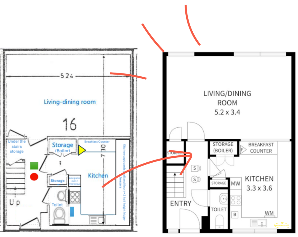
To see how this works in practice, consider a recent project we completed for a client named Alex. She needed to submit a floor plan to her local council for Property Licensing, but all she had was an old HM Land Registry deed scan.
The original scan outlined the basic structure, detailing a Living-dining room and Kitchen downstairs, alongside Bedroom 1 , Bedroom 2 , and Bedroom 3 upstairs. However, her council’s strict licensing criteria required exact locations of fixtures and fire safety equipment.
To bridge the gap, Alex sent us her old scan along with custom annotations. She clearly marked the location of crucial safety items, such as a fire/smoke alarm , a fire blanket , and fire extinguishers. She also provided links to online real estate listings of identical flats in her building, noting that her ground floor was a mirror image of the neighboring unit. Finally, she used photos to confirm the locations of large windows and built-in wardrobes.
By combining these different pieces of evidence, Houses and Properties was able to draft a clear, modern floor plan that met her needs without requiring a site visit.
What Information Helps Us Redraw a Floor Plan?
Many projects are completed entirely remotely. The more information supplied, the stronger the reconstruction becomes. Here is how we use the materials you provide:
| Information Source | What It Tells Us |
|---|---|
| Land Registry / Historic Plans | Provides the general framework, structural footprint, and rough room proportions. |
| Property Photographs | Reveals details that plans miss, such as window locations, door swings, stair layouts, and fixtures. |
| Similar Properties | Helps identify standard window positions, common wall alignments, and original design intentions. |
| Written Notes & Markups | Removes ambiguity. Simple annotations like “boiler cupboard under stairs” or “integrated oven” are incredibly helpful. |
Important Limitation: Compliance and Verification
While remote redraw services are often quicker and more cost-effective than arranging a site survey, a remote redraw is a graphical reconstruction, not a certified measured survey.
When clients require plans for property licensing, fire safety submissions, or HMO applications, certain information cannot be confirmed remotely. We cannot independently verify fire door specifications, smoke detector types, or building regulation compliance.
Our standard policy is clear: The plan will be produced based on the explicit measurements, photos, and instructions provided. Any safety symbols or annotations can be added exactly as instructed, but compliance and verification remain the responsibility of the property owner unless a physical site survey is undertaken.
Frequently Asked Questions
Can you create dimensions if I only have an old scan?
Often yes, although accuracy depends on available information and supporting references like photos or known standard door widths.
Can you use estate agent listings from similar properties?
Yes, but they are used as supporting evidence to understand the general layout rather than definitive measurements, as internal layouts often change over time.
Can you certify a plan for licensing?
Not through a remote redraw alone. Certification or compliance verification usually requires a physical survey. We draw what you instruct us to draw.
Can built-in cupboards and fixtures be included?
Yes. We can add wardrobes, boiler cupboards, kitchen units, appliances, and safety markers as long as you provide instructions on where they are located.